Libya Map
· Updated · BootsnAll
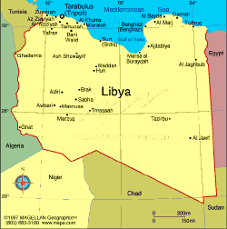 A basic map of Libya, the fourth largest country in Africa and the seventeenth largest in the world, and about 90 percent desert.
Where this stands in 2026. Two things are true at once, and most writing about Libya gives you only one of them. Libya is open to organised tourism: there is a working government e-visa, licensed Libyan operators run trips, and people go. It is not open to independent travel, and Western governments still advise against all travel to the country. The United States renewed its Level 4 "Do Not Travel" warning on 31 August 2026 and the British, Canadian and Australian advisories sit at their highest level. There is no US embassy operating in Libya; consular work is handled from Tunis. Both halves are true, and you need both to decide.
Three regions, which explains the politics
Almost everyone lives along the Mediterranean, on a coast that runs about 1,770 km. Tripoli, the capital, is in the west. Benghazi, the second city, is roughly 1,000 km east along the shore. The Gulf of Sidra between them is largely empty, and that emptiness has been the dividing line in every conflict the country has had.
Libya is traditionally three places rather than one. Tripolitania in the north west, around Tripoli. Cyrenaica in the east, around Benghazi, historically oriented towards Egypt and the Greek world. Fezzan, the vast south west, which is Sahara, oases and caravan routes looking towards the Sahel.
That division is not ancient history. The country currently has two rival administrations, the Government of National Unity in Tripoli and the Government of National Stability in the east, and a visitor meets that split as paperwork: the eastern region needs clearance beyond your visa, around 600 US dollars a head, and comes with a tourist police escort.
Borders are with Tunisia and Algeria to the west, Niger and Chad to the south, Sudan to the south east and Egypt to the east.
What is where
Libya has five UNESCO World Heritage Sites and they are spread across all three regions.
Leptis Magna, about 130 km east of Tripoli, is among the best preserved Roman cities anywhere, and it is the one people come for. Sabratha is on the coast west of the capital, with a theatre standing three storeys high above the sea. Both sit on the standard western itinerary.
Cyrene is in the east, a Greek foundation of the 7th century BC in the hills above Apollonia, its port. This is the eastern itinerary and the one that needs the extra permit.
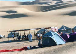
Ghadames, on the Algerian and Tunisian border, is a walled oasis town of covered streets built so you can cross it in shade. The Tadrart Acacus, in the far south west, holds rock art going back twelve thousand years, from the period when the Sahara was grassland with lakes and elephants.
The Ubari lakes, palm-fringed water in the middle of the dunes, are in the same part of the country.
The oil and gas fields that the economy actually runs on are concentrated in the Sirte basin in the centre and east.
A note on the map itself
This is an old outline and it is fine for the geography, which has not moved. Nothing on it indicates which authority administers which part of the country, and that has changed repeatedly since 2011.